Heavy rain forecast in central and southern regions
According to the National Centre for Hydro-meteorological Forecasting, a low pressure area recently formed to the north-east of the Philippines is predicted to strengthen into a tropical depression.
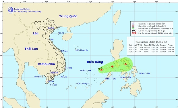 |
| The expected path of the low pressure area |
At 1.00pm on Thursday, the low pressure area was positioned at latitude 11°2’N and longitude 117°E, about 360km east-northeast of Song Tu Tay Island, part of the Truong Sa (Spratly) archipelago in the East Sea.
Over the next 24 hours, the low pressure area is expected to continue moving in an easterly or north-easterly direction at a speed of between 5kph and 10kph, and it is forecasted to strengthen into a depression.
At 1.00pm on 20 October, the depression’s position is predicted to be at latitude 12°5’N and longitude 120°E on the northern side of the Palawan Island in the Philippines.
In the next 24 to 48 hours, it is expected to continue moving in an easterly or north-easterly direction at a speed of between 10kph and 15kph.
Due to the effects of the low-pressure area associated with strong southwest monsoon winds, scattered showers, thunderstorms and strong winds at level 7/8 are expected to affect the central and southern parts of the East Sea, along with the coastal areas from Binh Thuan to Ca Mau provinces.
Da Nang and elsewhere in the central and southern region will experience moderate to heavy showers over the next few days due to the influence of the inter-tropical convergence zone and a cold air.
In particular, Da Nang and the provinces of Quang Tri, Thua Thien Hue and Quang Nam will have heavy rainfall of between 50mm and 70mm. The rainfall in Binh Dinh and Binh Thuan provinces will be between 20 and 50mm, and the provinces of Dak Lak, Dak Nong and Lam Dong 50 and 80mm.