Tropical storm Sanba heads towards Viet Nam
Tropical storm Sanba formed on late 11 February is expected to reach the Philippines on 13 February, and enter the East Sea during Tet (Vietnamese Lunar New Year) Festival.
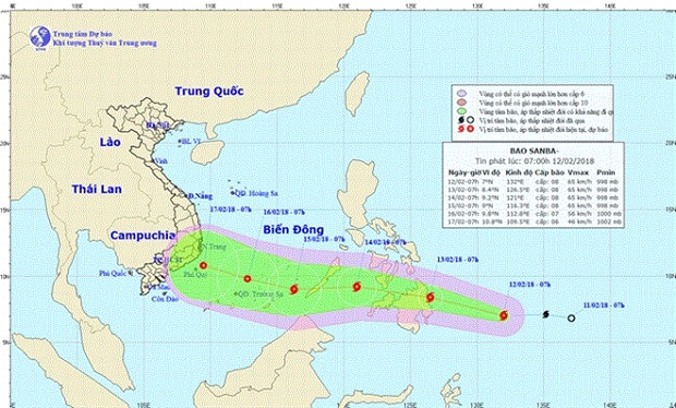 |
| Expected path of Sanba Storm (Photo nchmf.gov.vn) |
According to the National Centre for Hydro-Meteorological Forecasting, at 7.00am on 12 February, the centre of the storm was some 650km east of the Philippines’ southern coast, with wind speeds of up to 75kmph.
It is predicted that on 14 February morning, the storm is likely to be 270km from the east of the Philippines’ Palawan Island and will keep moving westward.
On 15 February morning, the eye of the storm will be some 450km to the east of Truong Sa Island, with wind speeds of 60-75kmph, sometimes up to over 100kmph.
Given the current forecast, Sanba is set to become the second storm to hit Vietnamese waters this year. It could pose threats to southeast Viet Nam during Tet, the main festival in the country, which fall this week.
The first storm in 2018 - Bolaven, formed on 3 January - was predicted to hit southern Viet Nam but weakened offshore shortly after entering the East Sea. Last year, 16 tropical storms hit the country.
The National Centre for Hydro-Meteorological Forecasting has predicted a warm Tet for the northern provinces as the cold spell weakens from 13 February.
In Da Nang, the weather in the first four days of the new year will be pleasant, with a temperature of some 25-28 degree Celsius. Rain is predicted on the 5th day and the temperature will drop to 20-23 degree Celsius.
According to the Central Steering Committee for Natural Disaster Prevention and Control, since the beginning of this year, cold spells in the northern and north central provinces have killed some 4,720 cattle and poultry. The latest cold spell, which started on 27 January and is expected to end on 13 February, has killed over 2,100 cattle and poultry.
(Source: VNA)