Storm No 5 set to batter northern provinces, super typhoon Mangkhut heading to East Sea
A strengthening tropical storm, also known as Barijat, is entering the East Sea, and may pack winds gusting up to level 12, according to the National Center for Hydro-Meteorological Forecasting (NCHMF).
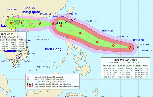 |
| The expected paths of storm No 5 and uper typhoon Mangkhut |
At 4.00 pm on Wednesday, 12 September, the eye of the storm was spotted at latitude 20°8’N and longitude 114°6’E, some 400 kilometers east-north-east of of Hainan Island in China, with maximum wind speeds reaching 60-90 kph (level 8-9), gusting at level 11.
At 4.00pm on Thursday, Barijat’s centre is expected to be positioned at latitude 20°9’N and longitude 110°0’E, right on the Leizhou Peninsula of China, about 240km east-southeast of the northern province of Quang Ninh, packing strong winds of 60-90 kph (level 8-9) near its eye (level 11-12) and gusts of level 12.
Barijat is expected to bring downpours and thunderstorms with gale-force winds to the northern East Sea, along with rough seas.
Within the next 48-72 hours, Barijat is forecast to move west-northwest at a velocity of about 20km per hour, and it is set to batter the coast stretching from Quang Ninh to Nam Dinh at 4.00am on Friday, 14 September.
Later, the storm is predicted to weaken into a tropical depression which is likely to move west and lose its power, turning into a tropical depression zone in Upper Laos.
Simultaneously, super typhoon Mangkhut is growing and it is heading the northern East Sea within the next 4 days, with maximum sustained winds of 200 kilometers per hour near the storm’s eye.
Mangkhut pummeled through Guam on Monday as it approached the Philippines through the Pacific.
According to the United States’ Weather Channel, as of Tuesday morning, Typhoon Mangkhut was equivalent in strength to a Category 4 (catastrophic damage) hurricane on the Saffir-Simpson Hurricane Wind Scale. It could pose a threat to parts of Southeast Asia by Friday or this weekend.
According to the Philippine Atmospheric, Geophysical and Astronomical Services Administration (PAGASA)’s forecast, Mangkhut will be felt in Northern and Central Luzon beginning Thursday or Friday.
With the approaching powerful storms, the National Steering Committee of Disaster Prevention and Control has already urged ministries, the relevant agencies and coastal localities from Quang Ninh to Quang Nam to make the necessary preparations to cope with storm No 5 and super typhoon Mangkhut.
Weather forecasters in Viet Nam have predicted that around four to six typhoons and tropical depressions could develop off the country's east coast from now until the end of the year. Around two to three storms will batter Central Viet Nam, they have said.
Da Nang is likely to see sunny and cloudy weather in the daytime with the temperatures hovering at between 27 to 34 degrees Celsius, whilst the lowest humidity is reported as around 68%.